
The Role of AI and Remote Sensing in Transforming Agriculture
In the realm of agriculture, especially in sectors like forestry, peatlands, and diverse crop types, understanding environmental parameters such as soil quality, humidity levels, and plant health is paramount. These elements directly influence the productivity and sustainability of agricultural practices. For instance, the ability to accurately assess soil composition and moisture content enables farmers and agronomists to make informed decisions about irrigation, planting, and harvesting schedules. In peatland environments, which are critical for both agriculture and environmental conservation, soil acidity and hydration play essential roles in ensuring healthy ecosystems and optimal peat extraction. Additionally, identifying plant diseases early is crucial for crop health, as timely interventions can prevent large-scale crop losses.
Remote sensing technologies offer a wide range of solutions for monitoring these critical agricultural variables. From soil quality analysis to real-time monitoring of peatlands, drones and satellite imagery can provide insights that traditional methods cannot match. For instance, peatland hydration forecasting relies heavily on accurately determining soil moisture levels across vast areas, which is crucial for preventing the degradation of these ecologically significant lands. Similarly, stored peat acidity monitoring ensures that peat, whether for fuel or agricultural use, is maintained in optimal conditions, preserving both its quality and utility. Applications extend to practical farming decisions as well. Harvest timing optimization, for example, is one area where remote sensing data plays a crucial role. By monitoring the humidity levels and hydration patterns of both peat and other agricultural plots, farmers can pinpoint the best times for harvesting, reducing waste and maximizing yield. These insights can also be applied to forestry and crop management, where moisture levels and soil quality directly affect plant growth cycles. Accurate data from remote sensing technologies enable better- informed decisions regarding planting, irrigation, and fertilization, which leads to more sustainable practices.
While remote sensing technologies provide a wealth of data, the integration of advanced AI, such as AGI, further elevates agricultural decision-making. Lu et al. (2023) highlighted the transformative potential of Artificial General Intelligence (AGI) in agriculture, with applications ranging from precision farming to farm automation and crop management. AGI can enhance various processes like crop yield prediction, disease detection, and soil quality assessment by utilizing advanced AI techniques such as computer vision and machine learning. The integration of AGI into agriculture promises to optimize resource use, improve decision-making, and foster sustainable practices. Furthermore, AGI can also revolutionize farm robotics, allowing them to perform tasks autonomously, thereby reducing labor costs and increasing efficiency. Remote sensing technologies gather vast amounts of data, but it is through advanced deep learning algorithms that these images are transformed into actionable insights for farmers and environmental managers (Lu et al., 2023).
Leveraging Remote Sensing Technologies for Precision Agriculture and Environmental Monitoring
Remote sensing technologies are transforming the way we monitor and manage agricultural landscapes. Drones, satellites, and advanced imaging techniques provide real-time, detailed insights into soil health, plant growth, and environmental conditions. One of the major advantages of remote sensing is the ability to gather data over large areas quickly and consistently, enabling farmers, researchers, and policymakers to make better-informed decisions. The types of cameras and sensors used in remote sensing vary in function and purpose. For instance, optical cameras capture images in the visible light spectrum, providing high-resolution visuals of land use and vegetation health. Multispectral and hyperspectral cameras go beyond the visible spectrum, capturing data in multiple bands to detect specific material characteristics.
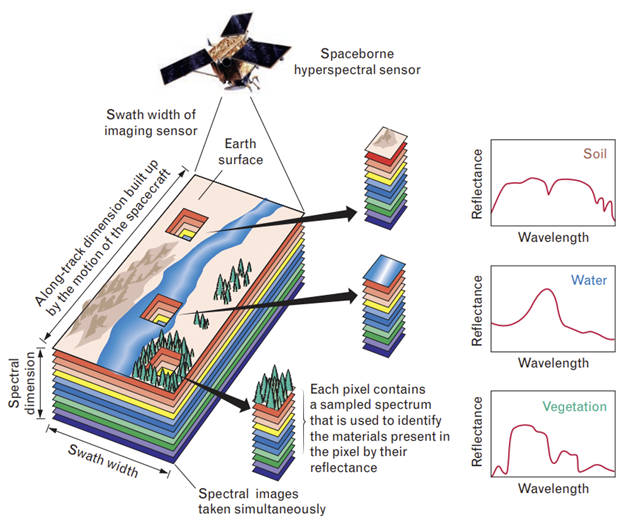
Figure 1. Concept principle of a hyperspectral satellite, Source: Qian, 2020.
Hyperspectral sensors, in particular, are vital for soil and material identification, as they can discern different soil types, moisture levels, and even the presence of organic matter or minerals. These sensors enable precision agriculture by offering detailed information that allows for site-specific interventions, such as fertilization and irrigation adjustments. In hyperspectral imaging (see figure 1), satellites capture data across hundreds of spectral bands, allowing for detailed material identification based on the reflectance patterns of soil, water, and vegetation. Each pixel in the image cube represents a unique spectral signature, enabling the differentiation of materials and their conditions, such as soil moisture and plant health. This rich data enables more precise management of agricultural resources, improving crop yield through targeted interventions. Hyperspectral sensors also provide early detection of plant stress, facilitating proactive measures to prevent crop loss, making them indispensable tools in sustainable agriculture.
Synthetic Aperture Radar (SAR) is another powerful tool used in remote sensing, particularly in agriculture and environmental monitoring. Unlike optical sensors, SAR works in all weather conditions and can penetrate through vegetation and soil layers, making it ideal for measuring soil moisture and peatland humidity. SAR uses radar backscatter signals to generate detailed surface images, enabling researchers to monitor the physical characteristics of the land over time. This is especially useful in regions prone to rapid environmental changes or where weather conditions would otherwise obscure satellite imagery. SAR’s ability to track subtle changes in moisture levels makes it a key technology for peatland monitoring, ensuring the maintenance of healthy ecosystems.
By integrating data from these various remote sensing technologies—optical, multispectral, hyperspectral, SAR, and thermal—agricultural systems can be monitored with unparalleled accuracy. Combining these sensors allows for comprehensive data collection that can then be matched with in-situ measurements, improving the overall accuracy of monitoring efforts. For instance, by combining hyperspectral imaging with SAR data, researchers can not only detect soil moisture levels but also understand how these levels change over time, which is crucial for managing peatland hydration and preventing environmental degradation.
Harnessing Deep Learning for Agricultural Image Analysis and Field Measurement Mapping
In agricultural systems, deep learning algorithms play a vital role in linking remote sensing images with on-field measurements. These algorithms can analyze large datasets of satellite and drone images, extracting meaningful patterns that relate to soil quality, crop health, and environmental factors such as moisture and temperature. The process starts with the collection of remote sensing data in various formats (optical, hyperspectral, multispectral, SAR, or thermal), which is then processed to identify specific features or classes related to agriculture, like soil type, crop growth stages, and disease detection. The satellite and drone images act as inputs for the machine learning model, which is trained using labeled datasets that include in-situ measurements from the field.

Figure 2. Deep Learning Workflow, Mapping Remote Sensing Images to Agricultural Measurements
In the deep learning process, satellite or drone imagery is first converted into a mosaic dataset, with each pixel representing different classes or measurements, such as soil moisture, crop health, or land type. These pixel values are then aligned with corresponding in-situ measurement data, such as field sensor readings. Deep learning models, including convolutional neural networks (CNNs), are trained on this dataset to identify patterns and relationships between the imagery and the field measurements. The model can then make predictions, creating a system capable of classifying different land types, evaluating soil quality, and predicting environmental stresses like water deficits across large agricultural landscapes. Figure 2 illustrates this training process, showing how the model learns to link image data with real-world agricultural measurements.
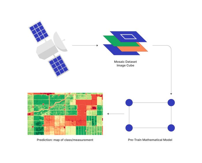
Figure 3. Predictive Mapping from Pre-Trained Deep Learning Models Using Remote Sensing Data
Once the deep learning model has been fully trained, it can predict agricultural measurements without requiring additional field data collection, streamlining the process. This is particularly useful in large-scale agricultural monitoring, where real-time predictions can optimize resource management. Figure 3 illustrates this predictive phase of the process. In this phase, satellite or drone imagery is converted into a mosaic dataset, just as it was during the training phase. However, instead of comparing the pixel values with in-situ measurements, the pre-trained mathematical model uses the input images to predict key measurements or classifications, such as soil moisture, crop health, or land type. This results in a detailed map that highlights the predicted classes or conditions across the observed landscape, helping farmers or decision-makers make informed choices without needing to collect additional ground measurements. This predictive capability is essential for efficient, real-time agricultural monitoring and management, ensuring that resources are applied where needed most, based on accurate and up-to-date remote sensing data.
Building upon these deep learning capabilities, Singh et al. (2023) developed an advanced approach for estimating surface soil moisture using multi-sensor satellite images from Sentinel-1 and Sentinel-2. Their fully connected feed-forward artificial neural network (ANN) model combines data from radar backscatter and optical imagery, integrating features such as polarization data, vegetation indices, and topographical information. By training the model with in-situ measurements, the ANN demonstrated superior accuracy compared to other machine learning techniques, including Random Forest and Support Vector Regression. This method enhances precision in predicting soil moisture levels at both high spatial and temporal resolutions, offering valuable insights for irrigation, crop management, and flood prediction. This innovative approach underscores the critical role deep learning plays in revolutionizing agricultural monitoring and decision-making.
Simulating Agricultural and Environmental Processes: The Power of Digital Twins
Simulations play a critical role in agricultural management by allowing decision-makers to model various scenarios and predict their outcomes before implementing them in the real world. One emerging application in the agricultural and environmental sectors is the use of digital twins, which are virtual replicas of physical systems that can simulate processes and predict changes over time. In agriculture, digital twins can be used to model land cover changes, soil quality variations, and crop growth patterns under different environmental conditions. These simulations allow farmers and researchers to experiment with various interventions, such as irrigation strategies or land management techniques, in a risk-free environment before applying them in the field.
One of the major benefits of these simulations is the ability to predict land cover changes over time. By analyzing historical data on land type and environmental conditions, the models can estimate the likelihood of changes such as deforestation, degradation, or shifts in agricultural land use. This predictive capability is especially valuable for agricultural land restoration planning, as it allows managers to simulate the long-term impact of different restoration strategies. For example, they can model the effects of rehydrating or introducing different vegetation types and predict how these changes will affect the overall ecosystem, including the potential for future fires.
A prominent xample of fire management in peatlands comes from the work of Widyastuti et al. (2020), who developed an agent-based model (ABM) called PeatFire to simulate fire ignition and spreading in tropical peatlands. Their model integrates key environmental factors, such as water table depth, biomass, and human activities, to predict fire patterns. By simulating interactions between human behavior and natural peatland conditions, the model helps decision-makers understand how fires spread and what interventions are most effective in reducing fire risks. This tool is especially valuable for managing tropical peatlands, where fires have significant ecological and economic consequences. The model provides insights into effective fire management strategies, offering a virtual environment to test interventions that can mitigate the risk of fire in peatland regions (Widyastuti et al., 2020).
Overall, these simulations are invaluable for planning and risk mitigation in agriculture and environmental management. By using remote sensing data, such as satellite imagery and SAR data, to feed into the models, researchers can create highly accurate simulations of environmental processes. These simulations not only help in decision-making but also in long-term planning, ensuring that interventions are both efficient and sustainable. Whether it’s predicting the best time for harvest, restoring degraded peatlands, or preventing fires, digital twins provide a powerful tool for modern agriculture and environmental management.
By integrating cutting-edge AI, remote sensing technologies, and simulation models, the agricultural sector is becoming more efficient, resilient, and sustainable. From improving crop yields to mitigating environmental risks, the future of agriculture lies in harnessing these innovations. Whether you’re a researcher, farmer, or policymaker, understanding and applying these technologies is crucial for long-term success.
Reference:
- Balsamo, G., Agusti-Parareda, A., Albergel, C., Arduini, G., Beljaars, A., Bidlot, J., … & Zeng, X. (2018). Satellite and in situ observations for advancing global Earth surface modelling: A review. Remote Sensing, 10(12), 2038.
- Li, J., Xu, M., Xiang, L., Chen, D., Zhuang, W., Yin, X., & Li, Z. (2024). Foundation models in smart agriculture: Basics, opportunities, and challenges. Computers and Electronics in Agriculture, 222, 109032.
- Lu, G., Li, S., Mai, G., Sun, J., Zhu, D., Chai, L., … & Liu, T. (2023). Agi for agriculture. arXiv preprint arXiv:2304.06136.
- Qian, S. E. (2020). Hyperspectral satellites and system design. CRC Press.
- Singh, A., & Gaurav, K. (2023). Deep learning and data fusion to estimate surface soil moisture from multi-sensor satellite images. Scientific Reports, 13(1), 2251.
- Widyastuti, K., Imron, M. A., Pradopo, S. T., Suryatmojo, H., Sopha, B. M., Spessa, A., & Berger, U. (2020). PeatFire: an agent-based model to simulate fire ignition and spreading in a tropical peatland ecosystem. International Journal of Wildland Fire, 30(2), 71-89.

About author
Dr. Valentas Gružauskas is an expert in AI governance, conformity assessment, and ethical AI applications. As an Associate Professor at Vilnius University and CEO of AI Conformity & Research Consulting, he leads initiatives in AI regulation and ISO standards. He actively participates in AI governance through the Horizon Europe Programme and various standardization committees. Dr. Gružauskas has made significant contributions to fields like machine learning, deep learning, and agent-based modeling, with a focus on AI ethics and data depersonalization. His work is widely published in esteemed journals, reflecting his impact and recognition in the AI community.